Award Holder: Jonathan S. Lim
University: University of Oxford
Title of Research: Finding the "Old Villages ": Developing a new protocol for understanding the cultural landscapes of Southwest Alaska using ethnography, public engagement, and spatial technology
Introduction
My name is Jonathan Lim, and I am a DPhil student at the University of Oxford. My project takes place in Alaska’s Yukon-Kuskokwim (Y-K) Delta, an expanse of windswept subarctic wetland, formed from where two vast salmon-bearing rivers flow into the Bering Sea (Figure 1).

For much of the year, the tundra is covered in ice and snow, but during the warmer months and calmer winds of June to September it is a lush, green landscape veritably teeming with life. In this harsh land of cyclical scarcity and abundance and live the Yup’ik people, whose ancestors have called this place home for at least a thousand years (Fienup-Riordan, 2007).
The Yup’ik live in traditional communities that subsist heavily on coastal and riverine resources, such as salmon, sea mammals, and edible beach vegetation, migrating between small subsistence camps throughout the landscape as needed (Fienup-Riordan, 2007). The soft fluvial sediments of the Y-K Delta are in a constant state of flux—accordingly, landscape change is very much an integral part of the cultural consciousness and cosmology of the Yup’ik people (Fienup-Riordan, 1995). However, in recent years the rate of climate-change induced erosion is accelerating at an alarming and unsustainable rate, posing an existential threat to modern infrastructure and heritage alike. The people of Newtok, for instance, are among the first climate-change refugees of the 21st century; in 2018, they were forced to relocate their village due to unchecked erosion (Ristroph, 2021), relinquishing generations of specialised local subsistence knowledge in the process.
Quinhagak and Nunalleq: A Tale of Two Villages
After decades of having their cultural practices, beliefs, and languages suppressed by colonial entities, the resilient Native peoples of Alaska have successfully brought about a period of cultural revival in recent decades. It is in the spirit of this movement that archaeologists were first invited to Quinhagak in 2009— Ancient wooden artefacts had started washing up on the beach near this community of 700 people by the shore of the Bering Sea (Figure 2).

To residents of the village, this was a sign that an ancestral village somewhere on the coast was eroding and on the cusp of being destroyed. Rather than allow the site and the ancestral knowledge contained within to be lost, the community decide to break with convention by seeking outside help (Williams, 2017; Knecht and Jones, 2019). Archaeologists from the University of Aberdeen under Dr. Richard Knecht were able to locate the abandoned 17th century site that the community has named Nunallleq (meaning, “Old Village”), partnering with Quinhagak to spearhead a major community archaeology project that persists to this day. Over 100,000 artefacts have been recovered and housed in a first-of-its-kind rural museum and conservation laboratory: the Nunalleq Archaeology and Cultural Centre. This has resulted in a resurgence of Yup’ik traditional practices in Quinhagak— for example, village youth have formed a Yup'ik dance group a century after it was banned by missionaries, and traditional ivory carvers add the designs of Nunalleq artefacts to their repertoires to sell as a source of income.
It is in this spirit of collaboration and power sharing, fostered over a decade of the Nunalleq Project’s success, that my doctoral research is grounded (Lim et al., 2021). Prior research has focused exclusively on the Nunalleq site, but my work is a survey of the cultural landscape in the immediate vicinity of Quinhagak, an approximately 200km² area encompassing its two major rivers. There are two broad components to the work:
- Developing new methodological frameworks for mapping and protecting heritage using ethnographic interviews and technology
- Building capacity for heritage management through training and automating data processing
New survey techniques for cultural landscapes
In 1999, Joseph Pleasant, then an employee of the Tribe of Kwinhagak, was tasked with creating a list of places around Quinhagak with traditional Yup’ik placenames. His superior, then-mayor Willard Church states that this work was crucial to prevent outsiders from erasing these names from the record by imposing their own. His work produced a list of around 120 cultural sites, ranging from hunting/fishing camps, berry picking spots, and entire abandoned villages. Some of these sites are potentially hundreds of years old (Figure 3). I have mapped these places based on Pleasant’s coordinates and descriptions, and these form the basis of a dataset to test new mapping techniques with remote sensing technology.

With the generous support of the RAI/Sutasoma Trust Emslie Horniman scholarship fund, I have conducted two field seasons in 2021 and 2022 to develop these methodologies alongside my external supervisor Dr Sean Gleason (Hampden-Sydney College, USA). Preliminary work in 2021 proved successful in showing that cultural sites do indeed have a vegetation signature that is easily quantifiable through sensors mounted on unpiloted aerial vehicles (UAV, aka Drones) (Lim et al., 2022). In 2022, I continued this work with a larger UAV with specialized sensors, capable of capturing data over vast swathes of terrain (Figures 4 and 5).


UAV-collected data is superior to satellite images for their higher resolution. From a data sovereignty standpoint, UAV images collected locally is owned by the community and not a satellite imaging company. Ethnographic interviews with community members were crucial for understanding the landscape of the past and present in all its wonderful cultural complexity (Figure 4)
Table 1: A selection of ethnographic interviews in Quinhagak carried out to understand the landscape

A large swathe of terrain (almost 56km2), representing almost the entire lower course of the culturally important Agalig river has been surveyed with the UAV, and work has begun on prospecting for undocumented cultural sites that are at risk from erosion. A few promising sites have almost certainly been identified (Figure 6), and data processing is still underway at time of writing.

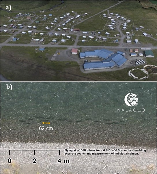
I was also able to carry out UAV work that were not directly tied to my PhD research—these surveys were requested by the community, and flagged as being particularly important for future town planning (Figure 7).
Empowering a new generation of Yupiit: Nalaquq LLC and building capacity in rural Alaskan communities
As demonstrated above, a multidisciplinary and multiple spatial dataset approach that engages with the community is a robust means of understanding Yup’ik landscapes. My priority now is to optimise these procedures in a coherent manner and automating the processing workflow, allowing other heritage professionals within rural Alaska communities to deploy them as they see fit.
As part of this effort, and a culmination of my long-term collaborative relationship with Quinhagak, I have co-founded with them a spatial technology and heritage management company: Nalaquq, LLC (Figure 8).

We have already begun training community youth in our methodologies (Figure 9), and I hope to continue these efforts beyond my PhD until this company is fully operational, staffed with Alaska Native people who are armed with additional skillsets to protect their heritage— both in Quinhagak and in other communities in the Y-K Delta.

Bibliography
Fienup-Riordan, A. (1995) Boundaries and Passages: Rule and Ritual in Yup’ik Eskimo Oral Tradition. University of Oklahoma Press.
Fienup-Riordan, A. (2007) Yuungnaqpiallerput/The Way We Genuinely Live. University of Washington Press.
Knecht, R. and Jones, W. (2019) ‘“The Old Village”: Yup’ik Precontact Archaeology and Community-Based Research at the Nunalleq Site, Quinhagak, Alaska’, Études Inuit Studies, 43(1–2), pp. 25–52. Available at: https://doi.org/10.7202/1071939ar.
Lim, J.S. et al. (2021) ‘Nuna Nalluyuituq (The Land Remembers): Remembering landscapes and refining methodologies through community-based remote sensing in the Yukon-Kuskokwim Delta, Southwest Alaska’, Archaeological Prospection, 28(3), pp. 339–355. Available at: https://doi.org/10.1002/arp.1840.
Lim, J.S. et al. (2022) ‘UAV-Based Remote Sensing for Managing Alaskan Native Heritage Landscapes in the Yukon-Kuskokwim Delta’, Remote Sensing, 14(3), p. 728. Available at: https://doi.org/10.3390/rs14030728.
Ristroph, E.B. (2021) ‘Navigating climate change adaptation assistance for communities: a case study of Newtok Village, Alaska’, Journal of Environmental Studies and Sciences, 11(3), pp. 329–340. Available at: https://doi.org/10.1007/s13412-021-00711-3.
Williams, A. (2017) ‘Alaska’s Thaw Reveals—and Threatens—a Culture’s Artifacts’, National Geographic [Preprint], (April).